Residents Urged to Stay Alert Amid Severe Thunderstorm Warnings and Tornado Threats
📍 Latest Update: Tornado Watch Active in Multiple States
As turbulent skies dominate much of the central United States, the National Weather Service (NWS) has issued a tornado watch for parts of the Midwest and Great Lakes regions, including western Michigan. Accompanied by a severe thunderstorm warning, today’s weather pattern is a stark reminder of the intensity and unpredictability of springtime weather storms and tornadoes.

Local authorities, including Wood TV 8, are advising residents to remain vigilant as the radar continues to detect rotating storm cells capable of producing large hail, damaging winds, and potentially devastating tornadoes.
🌪️ What Does a Tornado Watch Mean?
A tornado watch means conditions are favorable for the development of tornadoes in and near the watch area. It does not mean that a tornado has been spotted — yet — but it signals a heightened level of alert.
✅ Tornado Watch = Be Prepared
❌ Tornado Warning = Take Immediate Action
When the National Weather Service issues a tornado watch, it advises residents to:
- Monitor local media for updates
- Identify shelter locations
- Charge communication devices
- Have a basic emergency kit ready
The NWS uses advanced Doppler radar systems to detect possible rotation in storm clouds, which is often a precursor to tornado formation. Wood TV 8’s weather team is broadcasting constant updates using high-resolution weather modeling.
⚠️ Tornado Warning vs. Severe Thunderstorm Warning: What’s the Difference?
Many people confuse the difference between a tornado warning and a severe thunderstorm warning — but the distinction can be life-saving.
Tornado Warning
A tornado warning means a tornado has been spotted by trained storm spotters or confirmed by radar. Warnings are typically issued for small areas and are time-sensitive, urging immediate sheltering.
Severe Thunderstorm Warning
This warning signals a storm capable of producing winds of 58 mph or higher and/or hail at least one inch in diameter. These storms can still be dangerous and may transition into tornadic storms.
Why the Difference Matters
The key distinction lies in the action required. A tornado warning demands immediate action, while a severe thunderstorm warning calls for heightened awareness and preparation.

🛁 How Radar Detects Dangerous Storms
The latest radar scans reveal supercell thunderstorms forming along a potent cold front. These supercells are notorious for spawning long-track tornadoes due to their strong rotating updrafts.
Key Radar Observations:
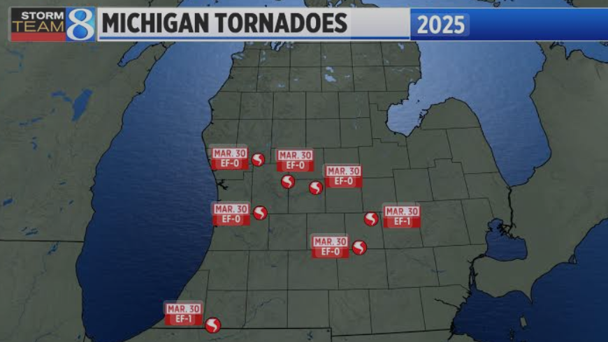
- Rotation signatures near Kent, Ottawa, and Allegan Counties
- Elevated reflectivity, indicating large hail
- Bowing segments on radar reflect intense wind gusts
- Velocity scans showing clear inflow notches—often precursors to funnel development
Wood TV 8’s mobile weather lab has been closely tracking these developments using cutting-edge dual-polarization radar.
🗺️ Impact Zones: Areas Under Tornado Watch
According to the National Weather Service, the following areas are under a tornado watch or severe thunderstorm warning:
- Michigan: Grand Rapids, Muskegon, Kalamazoo, and surrounding areas
- Indiana: Fort Wayne, South Bend
- Illinois: Rockford, Peoria
- Ohio: Toledo, Cleveland
- Wisconsin and Iowa: Isolated regions facing storm cell movement
Wood TV 8 meteorologists are especially concerned about western Michigan, where terrain and Lake Michigan’s influence can intensify local storm conditions.
🌀 Tornado Safety Tips: How to Prepare
If you’re in an area affected by a tornado watch or warning, here are crucial safety measures:
✅ Before the Storm:
- Charge phones and battery packs
- Tune into Wood TV 8 or radio alerts
- Review shelter options and gather your household
- Assemble an emergency kit with water, snacks, flashlight, first aid, and weather radio
⛑️ During a Tornado Warning:
- Head to a basement or interior room away from windows
- Mobile home residents should move to a sturdier structure
- Avoid elevators
- If caught outside or in a vehicle, lie flat in a low area, covering your head
❌ Common Mistakes to Avoid:
- Never take shelter under a highway overpass
- Don’t wait for visible signs – act as soon as the alert sounds
- Avoid taking videos during the storm – your safety is priority
🌍 The Science Behind Tornado Formation
Tornadoes form when warm, moist air from the Gulf meets cool, dry air from Canada, creating instability. Wind shear, or changing wind direction and speed with altitude, helps produce rotating updrafts known as mesocyclones.
These mesocyclones are the birthplaces of tornadoes and are most common in supercell thunderstorms, which are currently prevalent across the central U.S.
Meteorologists are noting increased storm activity in 2025 due to:
- An active El Niño pattern
- Higher-than-average surface temperatures
- A strengthened jet stream steering storms eastward
🧠 Did You Know?
- A tornado can form in as little as 5-10 minutes after a storm starts rotating
- The U.S. experiences over 1,200 tornadoes annually
- Michigan averages 15-20 tornadoes per year, though 2025 may exceed that
- The strongest tornadoes can have wind speeds over 200 mph
📰 Local Coverage: Wood TV 8 Reports from the Ground
Wood TV 8 has teams spread across western Michigan, capturing live footage of storm conditions, emergency responses, and property damage.
Their coverage includes:
- Interviews with local residents in affected neighborhoods
- Live radar tracking from their Storm Team 8 Mobile Lab
- Up-to-the-minute social media updates and video snippets
Meteorologist Ellen Bacca emphasized: “Even if it looks calm, take watches seriously. Things can change in minutes.”
🔔 How to Stay Informed
Timely information can save lives. Here’s how to keep up with developments:
Recommended Tools:
- NOAA Weather Radio
- Wood TV 8 Live Broadcasts
- Weather radar apps (RadarScope, MyRadar, AccuWeather)
- Emergency Alert Systems (EAS) via phone carriers
- Follow @NWS, @WOODTV, and local meteorologists on Twitter/X
🤔 Frequently Asked Questions (FAQ)
❓ What’s the difference between a tornado watch and a tornado warning?
A tornado watch means tornadoes are possible. A tornado warning means one has been spotted or shown on radar and immediate action is required.
❓ How does radar detect tornadoes?
Doppler radar detects changes in wind direction and speed. If opposing winds are close together, it signals rotation, a precursor to tornado formation.
❓ Can tornadoes happen at night?
Yes, and they are more dangerous at night due to reduced visibility and slower public response.
❓ How do I know if I’m in a tornado watch area?
Check with Wood TV 8, National Weather Service alerts, or reliable weather apps.
❓ What should I include in my tornado emergency kit?
Water, non-perishable food, flashlight, extra batteries, whistle, first aid, necessary medications, weather radio, and a map of your area.
📍 Summary
What is a Tornado Watch?
A tornado watch is issued by the National Weather Service when weather conditions are ideal for tornadoes. It signals to be prepared and stay alert. A tornado warning means take shelter immediately. Use radar updates, watch Wood TV 8, and follow weather storms tornadoes news for live updates.

⚠️ Final Word: Don’t Wait, Prepare Now
With tornado watches and severe thunderstorm warnings issued across multiple states, especially in Michigan, preparation is key. These weather storms and tornadoes are highly unpredictable and can escalate rapidly.
Keep your emergency kit handy, follow Wood TV 8 and the National Weather Service, and stay updated via radar and trusted alerts. Your awareness today can protect your family, your home, and your community.
Stay safe. Stay informed.

 By
By